Winter Storm Slams South Korea: Powerful Blast Hits in March
On March 18, an unusual "winter typhoon" is hitting South Korea, causing significant snowfall and intense gusts of wind because of a polar low-pressure system generated by extremely cold Arctic air. With temperatures plummeting as low as -40°C, this weather phenomenon is leading to widespread blizzard-like conditions. In Seoul, officials have issued their most recent heavy snow alert ever recorded, anticipating accumulations of up to 10 centimeters. It’s worth noting that this event represents only the second occurrence in six years where a potent polar low—with sustained winds approaching 20 meters per second, similar to those seen during a tropical storm—has traversed through the nation.
On March 17, as reported by the Korea Meteorological Administration (KMA), a frigid air mass from the Arctic swept across the warm waters of the West Sea during the night, forming intense snow clouds. Consequently, most regions of the nation face severe snow warnings on March 18, surpassing Seoul’s earlier record for the latest such alert, which was previously recorded on March 9, 2010.
The forecast predicts snow accumulation ranging from 3 to 10 centimeters in Seoul and nearby districts, 3 to 30 centimeters in Gangwon Province, 1 to 15 centimeters in the Gyeongsang area, 1 to 10 centimeters in Chungcheong, 1 to 8 centimeters in the Honam region (including Gwangju and Jeolla provinces), and 1 to 5 centimeters atop Jeju Island’s mountains. Snowfall rates could be as high as 3 to 5 centimeters per hour in Gangwon’s mountainous zones, whereas other locations might face accumulations of 1 to 3 centimeters each hour. Additionally, some places might receive rainfall totaling between 10 to 20 millimeters instead.
Since March 16, Gangwon and the East Coast have experienced significant snowfall because of powerful easterly winds. By March 17, certain locations had recorded more than 40 cm of snow, including 42.5 cm in Hongcheon, 38.4 cm in Samcheok, and 34 cm in Daegwallyeong. Given forecasts for further snow, accumulations may eventually match those typically observed during midwinter months.

The snowstorm is caused by a polar low. The collision between freezing cold Arctic air and warmer sea surface temperatures of about 10°C generates extremely unstable weather patterns, leading to the development of a rotating low-pressure area. As colder air is denser, it quickly descends, strengthening the whirlwind closer to the ground level. Essentially, this phenomenon represents a polar low—a type of cyclone that emerges from polar areas such as the Arctic region.
These systems unleash gale-force winds comparable to those seen during typhoons. Although typhoons demand sustained wind velocities of at least 17 meters per second, certain polar lows transitioning over land can whip up gusts as high as 20 meters per second. On March 18th, strong breezes buffet Seoul along with the broader capital area and parts west of South Korea. As this weather pattern races swiftly from west to east throughout the nation, it maintains wind speeds hovering near 15 meters per second, resulting in severe conditions akin to a tropical cyclone but marked by snowfall rather than precipitation. Additionally, thunderstorms coupled with flashes of lightning might be part of these meteorological events.
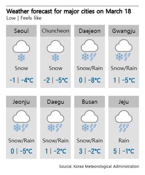
The chilly conditions will persist as the polar low-pressure system brings frigid Arctic air. On March 18, morning temperatures are forecasted to hover around -3°C to 3°C, with afternoon readings climbing to between 3°C and 9°C. Wind chills have dipped to -4°C in Seoul and -8°C in Daejeon. The cold snap is anticipated to worsen further on March 19, with overnight lows dropping to -6°C to 1°C and peak temperatures reaching only 6°C to 10°C during the day.
For the first time in six years, since March 2019, a polar low has struck South Korea. During this event, intense gusts of wind accompanied by significant snowfall blanketed Jeongseon in Gangwon province with 15.9 cm, Pyeongchang received 15.1 cm, and Hongcheon saw 14.3 cm. Similarly, winter-like precipitation impacted Gapyeong in Gyeonggi province with 6 cm and Bonghwan County in North Gyeongsang province with 12.6 cm. Additionally, powerful winds led to the sinking of a 44-ton tugboat close to Songi Island off Yeonggwang, resulting in one individual being unaccounted for. Furthermore, an electrical outage forced a halt to service on the Bundang Line between Wangsimni and Seoul Forest stations.